Showing posts with label Georgia. Show all posts

Wednesday, June 1, 2016

Potato Creek Mill and Dam in Thomaston, Georgia

The mill and Potato Creek Dam in the 1960s
Although the grist mill hasn't stood for 30 years or more, the site of the old mill and dam at Potato Creek in Thomaston, Georgia has fascinated me ever since I was a young child. I recall stories of the old mill told by mother, grandmother, and Aunt Anne as far back as I can remember. What fun they must have all had at Potato Creek Beach, as they called it.

I'm not entirely sure when the old mill was built, but I'm going to assume the late 1800s. I've heard it referred to as the old Reeves Mill as well as the Potato Creek Mill, but I'm not sure which is correct. My great grandparents, Thomas Alton Franklin and Ida Boggs Franklin, as well as their six children, lived in the mill from 1934 to 1937. Those six children were Wilmoth (my grandmother), Anne (my great aunt), Percy, Joe, Fred, and Andy. Thankfully Aunt Anne is still alive and she was able to tell me her first-hand account of what life at the mill was like. She informed me that they lived at the old mill itself until there was a big fire in 1936. The Franklin family had to live in the storage building, which was attached to the mill, for 3 months until the damage was repaired.

The site of the mill and what's left of Potato Creek Dam in May 2016

The mill in 1945.
A drawing by Sandra Herring depicting what the mill looked like historically (2000).

The site of the old mill can be found close to the intersection of Old County Road and W Moore's Crossing Road. Technically, in the heyday of the mill, that area was considered part of Upson County and not the Thomaston proper. Aunt Anne stated that a walk from the mill to her school, Robert E. Lee Institute was a 3.1 mile trek both ways. She and everyone else had to walk that each day come rain or shine.


Map of old mill site.


Tuesday, January 26, 2016

The Fall of the House of Stevens-Snider

Encompassed by venerable pecan and oak trees sits a house that must have been quite grand in its time. Architecturally, it would be classified as a vernacular farmhouse; however, the house would fit right in any Southern historic district of a city. From my research, I've determined the house was built circa 1910 and it is located between Buena Vista, Georgia and Ellaville, Georgia. Additionally, a local resident of the area has informed me that the house has been abandoned for thirty years or more and has not had any work done to it in ten years time.

I have been taking notice of the the Stevens-Snider house for over twenty years, and at one time, I hoped it might have been restored. However, since 2005 it has fallen in ill repair. The roof was no longer a suitable protector of the house beginning around 2010, and by 2012 the roof shingles were starting to come off. It wasn't long before more and more exposed wood became quite prominent leading to rot of the structure. It is now 2016 and so much wood has rotted that the second floor is now collapsing into the first floor.

The house appears to be rapidly returning declining, so if you would like to visit it, I suggest you do so as soon as possible. However, I advise against entering the home because it is private property, and structurally unsafe.

The house in 2010. 


I do not own this image and will remove it by request.

The house in 2012.


The house in 2016.


If you are traveling along Highway 26 from Buena Vista to Ellaville, the house is located on the left side of the highway right after the intersection of Highway 26 and Highway 112. It is about halfway between Buena Vista and Ellaville.

Monday, November 17, 2014

A Collection of Mint Postcards Featuring Columbus, Georgia Circa 1910

In addition to the postcards I've posted previously, I also purchased this collection of postcards I've acquired featuring Columbus, Georgia that are in mint condition. I do believe they were manufactured around 1910. It's amazing they are in such great condition and even more amazing that they were still in their original Kress packaging! Sadly only the facade of the old Kress building still exists, as the building succumbed to fire in 1994. 

The Confederate Monument is still there along with the house featured at the intersection of Third Avenue and 14th Street and the St. Elmo House. However, the St. Elmo house did burn in 2011, but was mostly undamaged. The Courthouse has been torn down and replaced with a 13 floor "skyscraper" built in 1973, much to the dismay of the city folk. And to my knowledge the Green Island Ranch is no longer standing, but a luxurious country club now exists on the site.

Original packaging from Kress 
Lower Broad Street (now Broadway), Showing Confederate Monument, Columbus, GA
Court House Square and Fountain, Columbus, GA
Green Island Ranch, Columbus, GA
Historical St. Elmo, Columbus, GA
Third Avenue and 14th Street, Looking South, Columbus, GA

Sunday, November 16, 2014

Antique Columbus, GA Postcards - Correspondence Between Two Sisters From 1909

Yesterday I went to a parking lot sale at The Gypsy Cherub antique store in what used to be Bibb City, GA (now part of Columbus). I saw some old Columbus postcards being advertised on Facebook, so I went down there early to make sure they were still there. And boy did Yvonne still have them! Postcards from Columbus, Americus, Atlanta, and all over Georgia with Alabama and Florida hiding in there as well.

Well, when I was looking through the postcards, I was mostly looking for familiar landmarks and landscapes of Columbus that held sentimental value, or at least offered artistic or historical value. However, after getting home and looking through them all, I discovered the true value was actually Dovie Smith and Elizabeth Smith - two sisters that corresponded via Columbus, GA postcards in the summer and fall of 1909.

I have taken the liberty of scanning both back and front of the postcards, as well as transcribing what is written on the postcards for easier reading. In addition, I have placed the cards in chronological order of correspondence. This required me finding a calendar from 1909, as two of the postcards are postmarked on the same day. I tried to leave the grammar and punctuation as accurate as possible.

I just wonder who were Miss Dovie Smith and Miss Elizabeth Smith? What was there story? I hope to further research these two women and possibly find more of their wonderful postcards. 

Postcard #1


Beech Grove, North Highlands Park, Columbus, GA.


To: Miss Dovie Smith
From: Miss Elizabeth Smith

"Chipley, GA 8/9/09

Dear Dovie, 
I reached here alright and am still at Aunt Nannies. We went to a singing yesterday afternoon and stayed until train time and we then went up to White S Springs and came back on the night train, had a very nice time. 
                                                   E. Smith"


Postcard #2


Chattahoochee Rapids, North Highlands Park, Columbus, GA


To: Miss Dovie Smith
From: Miss Elizabeth Smith

"Chipley, GA 8/13/09

Dear Dovie, 
How are you all getting along by this time I am at Jennies Williams have been here since Wednesday morning am going back to Chipley in the morning and (Gene?) and I are going Aunt Ellen's to spend Saturday night and Sunday. Will see you all soon.
                                                                 E. Smith"


Postcard #3


Eagle and Phenix (Phoenix) Mills, Columbus, GA

To: Miss Dovie Smith
From: Miss Elizabeth Smith

"Monday Morning
Well, I came out here at Uncle Pinkes Saturday afternoon and I guess I will stay a day or two. They are running the meeting at Beech Springs this week. I expect I will be home before long but don't know exactly when so you need not look for me until you see me. 
                                                                                                   E. S.


Postcard #4


 Lower Broad St. showing Confederate Monument, Golumbus, GA
(Broad Street is now known as Broadway)


To: Miss Lizzie (Elizabeth) Smith
From: Miss Dovie Smith

"Dear Sister: -
Received your postal Saturday, and we were glad to hear from you and that you are having such a nice time. I wrote you last week, thought you were still at Jennies. Love to all,
                                                                                                           "Dovie".


Bonus - Postcard #5


Wildwood Park, Columbus, GA
(I don't believe Wildwood Park still has ponds.)


To: Miss Dovie Smith
From: C. R.

"I received your card Monday would of answered sooner but didn't have any cards. I may be over at the (Jens?) (Gens?) Thursday night if nothing happens. hope to see you.
                                                                                  your friend C. R."

Monday, March 19, 2012


Columbus is in the process of blasting the old Eagle & Phenix dam along the Chattahoochee River dating back to 1882. They’re going to be blowing a 50 foot hole on the Phenix City, Alabama side (right in pictures) on Wednesday, which will be as loud as 20 cannons going off at the same time.


This is the first time I’ve ever seen no water coming over the dams in all of my years of existence. I’m really not sad to see it go though, because I know restoring the river to its natural flow is much better for the environment, and I’m glad that we’re going to have a stellar whitewater rafting course that will attract many tourists and adventurists. 


Original article from Ledger-Enquirer as followed:

Dam blasting set for Wednesday to sound like boom of 20 cannons

Authorities stress safety as 130 years of history break, topple into river

- tchitwood@ledger-enquirer.com
One hundred and thirty years of industrial history is about to open like a flood gate.

An explosion tentatively set for 3 p.m. Wednesday is to fracture a granite stone and masonry dam that has stood across the Chattahoochee River since 1882, when upon its completion the Sunday Enquirer newspaper called it “the largest granite dam in the South” and boasted, “It is fully accomplished and generations yet to come will see its durability.”

Some will see the durability of the Eagle & Phenix dam as Wednesday’s blast loosens its dense granite so the heavy stone crumples into the stream. Fragments may be propelled into the air, from whence they could plummet upon bystanders, were any allowed to stand by.

Columbus police Capt. J.D. Hawk, who’s heading security for this event, warns motorists frequenting downtown Columbus that at any time between 2 and 4 p.m., Front Avenue and the 13th Street river bridge could be shut down for 30-40 minutes.

Officers will sweep the streets and both the Columbus and Phenix City riverwalks for pedestrians, east and west clearing safety zones from Broad Street in Phenix City and Broadway in Columbus to the river’s edge. Broadway and Broad Street will remain open, Hawk said.

In Columbus, Front Avenue and Bay Avenue will be swept clear and closed down, from 14th Street to Dillingham Street. Hawk notes drivers with vehicles parked along those avenues won’t be able to leave during the blast time. If they want to travel between 2 and 4 p.m. that day, they should park outside the safety zone.
Along with Columbus and Phenix City police on the streets, Coast Guard and Georgia Department of Natural Resources officers will be out on the river to ensure no one fishing or boating goes into the blast area, Hawk said. A police helicopter will be overhead.

“In addition, the police helicopter will have infrared, and it will be flying over and checking to see if anybody might be hiding,” said Newt Aaron whose Aaron & Associates firm is managing the whitewater project for which the dam is being breached.

If anyone ventures into the cleared safety zone, the work will stop until the intruder is removed, Hawk said.
Uptown Columbus Inc. is arranging a safe viewing area in Woodruff Park, at 10th Street and Bay Avenue behind the Columbus State University Theatre Complex. Uptown Columbus President Richard Bishop suggests spectators park in the RiverCenter parking garage and walk. Signs will direct them to the viewing area, he said.

The blast
When completed in October 1882, the Eagle & Phenix dam was a formidable structure. The Sunday Enquirer put its length at 1,009 feet, its width 17 feet at the base and 15 feet above that.

“The height of the dam above the river bed is various, owing to the inequalities of the granite rock upon which it is built, ranging from 16 to 27 feet high,” the newspaper reported.

Today it is not its former self. Voids became apparent when water recently was diverted through the Eagle & Phenix powerhouse, Aaron said. Water started leaking through the dam’s downstream face.

“After they did drilling for the explosives, it seemed to tie some of those voids together and even more leaks sprang out,” Aaron said.
The Scott Bridge Company of Opelika, Ala., has drilled about 100 vertical holes through the dam from the top down. The bottom half of each will be packed with 2-inch sticks of dynamite, topped with a 2- to 3-foot layer of crushed gravel, and then more dynamite.

That layering puts most of the explosive power at the dam’s base, where it’s most needed, said Stephen Summers and Charles Davis of the Scott Bridge Company. Summers is the construction firm’s senior project manager. Davis is its vice president over engineering.

They anticipate this:
The explosion will be like a chain reaction, with 20 milliseconds or one 20,000th of a second between each tunnel blast. The effect is that one blast blows a gap that the next explosion widens, and the one after that widens both, similar to a zipper coming undone. This makes the most of the energy being expended, and it reduces the risk of flying rock that could result from an instant burst.
Further cutting that risk will be a blanket of heavy silt screen, reinforced with sections of chain link fence, that will cover the dam’s blast site. This first breach is to be 50 feet long, with the intent of creating a channel that drains half the dam’s backwater, narrowing the river.

Pressed by the river, the big rocks in the dam are expected to topple like blocks. Because of all the precautions, viewers needn’t expect to see a spectacular, action-movie eruption of debris, which would be dangerous.
But they can anticipate a boom that sounds like 20 cannons fired at once, the sound waves reverberating off the riverbanks.
Some flying debris still is possible within about a quarter-mile of the blast site. The designated viewing area at the end of 10th Street is more than a third of a mile away.

The aftermath
After the blast, crews will use heavy equipment to remove the rock and other debris. Then they’ll get ready for the next breach.
That could be as soon as next Sunday, when the same safety precautions would be taken as the Scott Bridge Company fractures a larger section of dam, about 75 feet.

Between the two gaps will be left standing about 100 feet of dam that, once isolated, can be removed through heavy equipment alone.
All of that work will be west of a concrete berm the company built in the riverbed to divert water from where they sculpted rapids near the Alabama bank.
Still left after that will be a section of dam on the Georgia side, adjacent to the Eagle & Phenix powerhouse and Columbus’ Chattahoochee RiverWalk. The breach on the Alabama side will so narrow the river that crews can install a service road along the eastern bank from a staging area at 14th Street, bring in equipment and start sculpting whitewater rapids for the river’s eastern channel.

That last section of dam is to be removed only with heavy equipment. Left on either side of the river will be wings of the former dam, each about 45 feet long, so that future generations can imagine what used to be.

The engineering

The explosive that’s to destroy the dam is the same used to build it: An estimated 3,000 pounds of dynamite went into the construction, said the 1882 Enquirer: “On some occasions as much as 75 to 90 pounds of dynamite was thus simultaneously discharged causing the whole earth in the city to tremble with the upheaval.”

Other tools were more primitive: Steam rock drills bored holes into the granite for dynamite, and sometimes hand drills were used. Eight boom derricks, each about 50 feet tall, together employing about 5,400 feet of wire rope for guy lines, were used to haul granite. A railroad track across the dam’s crest took three cars, each hauling about 2 tons of mortar, to where the granite blocks, each with a weight of 185 pounds per cubic foot, were sealed in place. More than a million tons of granite, 4,800 barrels of cement and 1,200 barrels of lime went into the dam, which took 250 workers to build.

Holes drilled into the bedrock were used to anchor guy wires for the boom derricks, precursors to modern-day cranes. “We found lots of pins, iron pins and drilled holes in the bedrock below there,” said Aaron. The pins anchored the wires.

Built to withstand floods that continually blew out early wood dams, the stone dam was designed, and its construction supervised, by John Hill, a gifted engineer who also designed and specially ordered equipment to fit Eagle & Phenix Mill No. 3. That’s the 19th century mill complex’s southernmost building, the one now remodeled into loft apartments -- where residents Wednesday will be warned to stay off their balconies as Hill’s dam is reduced to rubble.
Davis, the Scott Bridge engineering vice president, said the old dam remains a striking piece of industrial-age construction:

“It’s very impressive when you consider the tools that the men had at their disposal to build that back in that time,” he said.
Over the years the company has done a lot of demolition, at times undoing what took considerable effort to achieve decades ago.
“It’s always a solemn event,” Davis said, “because you’re undoing the work, the hard work, of a lot of good men.”

Read more here: http://www.ledger-enquirer.com/2012/03/18/1977124/opening-the-flood-gates-dam-blasting.html#storylink=cpy


Sources:  Chitwood, Tim. "Dam Blasting Set for Wednesday to Sound like Boom of 20 Cannons Read More Here: Http://www.ledger-enquirer.com/2012/03/18/1977124/opening-the-flood-gates-dam-blasting.html#storylink=cpy." Ledger-Enquirer.com. Ledger-Enquirer, 18 Mar. 2012. Web. 19 Mar. 2012. <http://www.ledger-enquirer.com/2012/03/18/1977124/opening-the-flood-gates-dam-blasting.html>.

Tuesday, December 27, 2011

Sears and Kmart and Columbus of Yesteryear

This morning as I read the paper about how Sears and Kmart plan to close 120 of its stores, I thought it would be interesting to go back and time and take a look at our old Sears, which is already gone, and our Kmarts, which will probably be gone soon.

Now, I tried to do a before and after photo shoot of how Macon Road looked back in October of 1984 (that's when the photo is dated but could be inaccurate) compared to December 27, 2011. After taking "After" photos and comparing them to the "Before" photo, I realized that the photo wasn't taken from the I-185 bridge over Macon Road, because the bridge wasn't even there! It must have been taken from the roof of possible the Mexican restaurant that stands there now, or maybe a cherry picker. Who knows.

Macon Road looking West - October 1984?


Macon Road looking West on the East side of I-185  - December 27, 2011


Now as you can see, it's hard to recreate the shot exactly as it was since there is a large bridge that now bisects the photo, but I took a photo on the East side of the bridge looking West, and right after crossing the West side. 

Even though 30 years have almost passed, there are still lots of identifying landmarks. McDonalds's golden arches still proudly rise above Macon Road, even though it's been torn down and rebuilt. Ironic that this is the second time it's been torn down and rebuilt. Before the newest McDonalds, a 1980s brown McDonalds stood at that location. It was always uninviting and after looking at this photo, I wish they had never torn down the original 1950s building, which looks almost identical to the oldest operating McDonalds, built in 1953. 

I'm not sure what the building was in the Before photo, but the building that housed the Ace Tire and Auto Center is still there, though it looks like it has been closed for a while. I never remember a Shoneys being there, even back when I was a little kid. I only remember the Captain D's being there, although it was painted monochrome blue all over, instead of the multi-color concoction that it is now. 

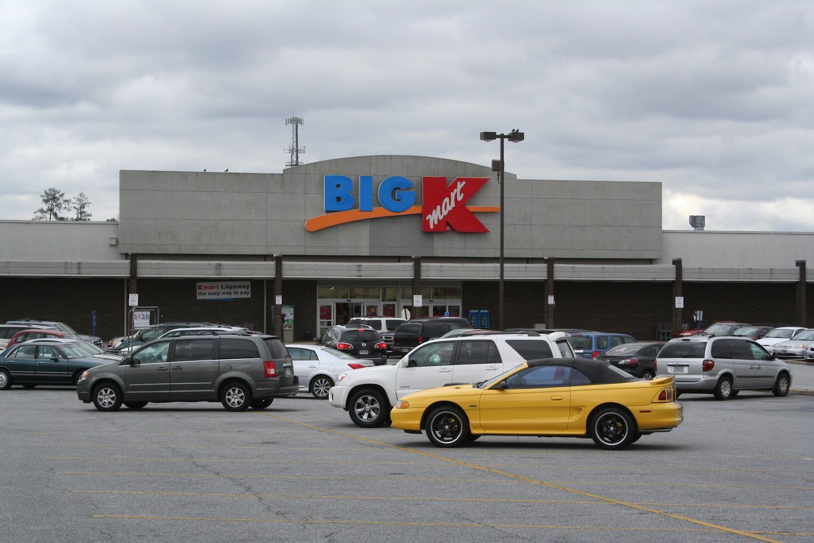
Even though the corporate logo has changed, the Kmart, and that loud red Kmart sign is still there, but now proudly displays a "BIG K" instead of just a regular one. Behind the Kmart sign, that same building that used to be a CB&T branch bank is still there, though it has long been closed. On the right of the photo, a heavily remodeled Cross Country Plaza is still there, but long gone is the almost forgotten Service Merchandise. 

Macon Road Looking West on the West side of I-185 - December 27, 2011


The only major difference between now and yesteryear is the Sears building and Columbus Square Mall that is now gone, and the Columbus Public Library and Muscogee County School District buildings that now stand in their place. 

I do remember the old Columbus Square Mall. I used to love going to the Corn Dog 7 over there, and shopping at the old Sears. Heck, even our current refrigerator that we have now came from the old Sears back in 1996. 


Columbus Square Mall Interior 1960s


Columbus Square Mall and Sears 1980s


Columbus Square Mall Exterior and Interior 1990s


The Sears logo is prominently displayed in the background.


These pictures are from Mike Dudley and show how almost everything, if not everything, was closed down inside the mall during the late 1990s with Sears being the only anchor store left open. I remember one of the last few times I went to the mall to buy a Jacuzzi tub at one of the hot tub stores, and also getting a corn dog from Corn Dog 7, which was about the only food venue left. That had to be no later than 1996 or 1997.

Digging around online, I found some old layout maps of Columbus Square Mall. 


Columbus Square Mall - 1965


Columbus Square Mall - 1975


Now of course, Sears no longer exists on this side of town, and is now located in Columbus Park Crossing. However, these are pictures of the Columbus Public Library and Muscogee County School District. 

Present Day Site of Columbus Square Mall 


Present Day Site of Sears (in-between the library and School District building)


Muscogee County School District Building - December 27, 2011


Expected Outcome Of Columbus Consolidated Government Center - Coming Soon


When this entire area is finished, it should look something like the rendered drawing. The Natatorium will house the large swimming pool that will be open to the public, and that parking lot looks like it will have room for a large Mercedes and pony. Hopefully the pony won't be put up wet since it's close to a swimming pool and sauna, mind you. And I don't know what is going to go on in the City Services Building - maybe that will be a large building where the mayor and city council compete athletically to decide who wins on city issues. *rolls eyes*

Macon Road looking East on West side of I-185 - December 27, 2011


Kmart on Macon Road - December 27, 2011


Kmart on Airport Thruway - December 27, 2011

Attention Kmart shoppers. Blue light special - aisle 13. Yeah, from the looks of these photos, they're not gonna be having too many more blue light specials. Who would want to shop there? The one on Macon Road has that lovely depressing brown exterior facade, and the one on Airport Thruway looks like a warehouse with "Big K" sign on it. 

The Kmart store on Airport Thruway was basically the store I grew up at, as my mom purchased almost everything from there. I've only been in there probably less than 10 times in the past 10 years, and it's always depressing. The electronics department has been out of stock of CDs since 2001, and one time I went in there to purchase a stapler, and they were out. Of staplers. Who doesn't restock staplers!? 

I won't be sorry to see the Kmarts go if they do indeed go under. They did it themselves. 

And can someone please put a damn dome on top of that library? 

[Sources] Photos courtesy of Mike Dudley and 

"Going Going Gone." Weird Georgia. Web. 27 Dec. 2011. <http://www.angelfire.com/weird2/georgia/page3.html>,
"September 2009." MALL HALL OF FAME. Web. 27 Dec. 2011. <http://mall-hall-of-fame.blogspot.com/2009_09_01_archive.html>.